Loading...
Searching...
No Matches
io/viewers/viewer3D-4-modes.cpp
Example of default visualization of a digital point sets with the associated domain
- See also
- Examples with Objet modes
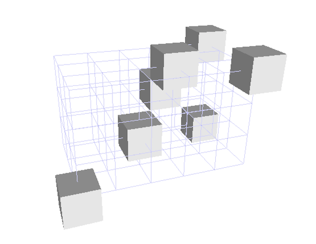
Illustration of the Paving/Grid modes on 3D points
#include <iostream>
#include "DGtal/base/Common.h"
#include "DGtal/helpers/StdDefs.h"
#include "DGtal/shapes/Shapes.h"
#include "DGtal/io/viewers/PolyscopeViewer.h"
using namespace std;
using namespace DGtal;
using namespace Z3i;
// Standard services - public :
{
PolyscopeViewer viewer;
Point p1( -1, -1, -2 );
Point p2( 2, 2, 3 );
Point p3( 1, 1, 1 );
Point p4( 2, -1, 3 );
Point p5( -1, 2, 3 );
Point p6( 0, 0, 0 );
Point p0( 0, 2, 1 );
viewer << p1 << p2 << p3<< p4<< p5 << p6 << p0;
viewer << domain;
// Draws point as balls instead of cubes
viewer.drawAsBalls();
viewer << p1 << p2 << p3<< p4<< p5 << p6 << p0;
viewer << domain;
// Draws a grid instead of cubes
viewer.drawAsGrid();
viewer << domain;
viewer.show();
return 0;
}
// //
void drawAsGrid(bool toggle=true)
void drawAsBalls()
Z3i this namespace gathers the standard of types for 3D imagery.
DGtal is the top-level namespace which contains all DGtal functions and types.
Definition ClosedIntegerHalfPlane.h:49
STL namespace.